
Faili:Bow echo diagram.svg

Size of this PNG preview of this SVG file: piseli 542 × 294. Ukubwa zingine: piseli 320 × 174 | piseli 640 × 347 | piseli 1,024 × 555 | piseli 1,280 × 694 | piseli 2,560 × 1,389.
Faili halisi (faili la SVG, husemwa kuwa piseli 542 × 294, saizi ya faili: 204 KB)
Muhtasari
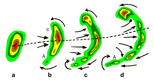
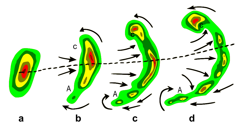
| Maelezo | Typical evolution of a thunderstorm radar echo (a) into a bow echo (b, c) and into a comma echo (d). Dashed line indicates axis of greatest potential for downbursts. Arrows indicate wind flow relative to the storm. Note regions of cyclonic rotation (C) and anticyclonic rotation (A); both regions, especially C, are capable of supporting tornado development in some cases. |
| Tarehe | Plain GIF version was uploaded to English Wikipedia as Bowecho1.gif on 9 Apr 2007 (UTC) by Utahweather. |
| Chanzo | Vectorization of http://www.srh.noaa.gov/oun/severewx/figure1.php |
| Mwandishi | National Weather Service |
| Ruhusa (Kutumia faili tena) |
Public domain |
This W3C-unspecified vector image was created with Inkscape .
Hatimiliki
This image is in the public domain because it contains materials that originally came from the U.S. National Oceanic and Atmospheric Administration, taken or made as part of an employee's official duties.
|
This work is based on a work in the public domain. It has been digitally enhanced and/or modified. This derivative work has been (or is hereby) released into the public domain by its author, Remember the dot. This applies worldwide.
In some countries this may not be legally possible; if so: |
Historia ya faili
Bonyeza tarehe/saa kuona faili kama ilivyoonekana wakati huo.
| Tarehe/Saa | Picha ndogo | Vipimo | Mtumiaji | Maelezo | |
|---|---|---|---|---|---|
| sasa hivi | 06:03, 11 Aprili 2007 | | 542 × 294 (204 KB) | Remember the dot | {{Information |Description=Typical evolution of a thunderstorm radar echo (a) into a bow echo (b, c) and into a comma echo (d). Dashed line indicates axis of greatest potential for downbursts. Arrows indicate wind flow relative to the storm. Note regions |
Matumizi ya faili
Ukurasa huu umeunganishwa na faili hili:
Matumizi ya faili ulimwenguni
Wiki nyingine hutumia faili hizi:
- Matumizi kwa af.wikipedia.org
- Matumizi kwa ca.wikipedia.org
- Matumizi kwa en.wikipedia.org
- Matumizi kwa en.wikibooks.org
- Matumizi kwa es.wikipedia.org
- Matumizi kwa fi.wikipedia.org
- Matumizi kwa fr.wikipedia.org
- Matumizi kwa it.wikipedia.org
- Matumizi kwa ja.wikipedia.org
- Matumizi kwa lmo.wikipedia.org
- Matumizi kwa mk.wikipedia.org
- Matumizi kwa nl.wikipedia.org
- Matumizi kwa pl.wikipedia.org
- Matumizi kwa pt.wikipedia.org
- Matumizi kwa sk.wikipedia.org
- Matumizi kwa sv.wikipedia.org
- Matumizi kwa zh.wikipedia.org